World History Maps – Welcome to Atlas of World History
History teaches us valuable lessons, and its philosophy shows us what mistakes we should avoid and engages people to look into their cultural heritage. A great way to visualize history is by studying history maps, graphic representations of past events.
The project started by Thomas Lessman, an amateur historian with over 20 years of experience in researching history, aims to show the readers how the rest of the world looked like in different time periods and ease searching for a complete world history map.
It is a great experience for world history enthusiasts to find map resources in one place, even for those still studying in school. If you are interested in a particular region, kingdom, or what was the name of a certain location thousands of years ago, you can find it all here, by browsing through our history maps!

World History Maps website
Since finding complete world history maps has always proven to be a daunting task, we decided to start drawing some world history maps and share this content for free. Our atlas of the World History Maps includes a series of historical maps, divided into five eras: prehistoric , primeval , ancient , medieval , and modern history maps.
Prehistoric Maps
(Early Humans to 3000 BC)
Prehistoric maps are in process now.
Primeval History Maps
(3000 BC to 601 BC)
3000 BC | 2400 BC | 2200 BC | 2000 BC | 1900 BC | 1800 BC | 1700 BC | 1600 BC | 1500 BC | 1400 BC | 1300 BC | 1200 BC | 1100 BC | 1000 BC | 900 BC | 700 BC | 650 BC | 625 BC
*4 Primeval maps currently finished.
Ancient History Maps
(600 BC to 499 AD)
600 BC | 550 BC | 549 BC | 540 BC | 527 BC | 500 BC | 400 BC | 350 BC | 335 BC | 323 BC | 300 BC | 250 BC | 220 BC | 200 BC | 150 BC | 100 BC | 50 BC
1 AD | 50 AD | 100 AD | 150 AD | 200 AD | 250 AD | 270 AD | 300 AD | 350 AD | 400 AD | 420 AD | 450 AD | 475 AD | 476 AD | 477 AD | 480 AD | 486 AD
*27 Ancient maps currently finished.
Medieval History Maps
(500 AD to 1500 AD)
500 AD | 510 AD | 525 AD | 535 AD | 550 AD | 565 AD | 600 AD | 610 AD | 700 AD | 750 AD | 800 AD | 850 AD | 900 AD | 950 AD | 1000 AD | 1025 AD | 1050 AD | 1100 AD | 1150 AD | 1200 AD | 1250 AD | 1300 AD | 1350 AD | 1400 AD
*13 Medieval maps currently finished.
Modern History Maps
(1500 AD to Present)
*1 Modern map currently finished.

World History Maps are used in dozens of Wikipedia history articles, and several historical sites link to them or use them directly, with our permission.
Each map is designed after thorough research, and it is based on the information available to us. This information is listed in the Sources section of the website ( worldhistorymaps.info ). Also, these history maps are updated as often as possible when new information becomes available to us. You can find out everything related to the latest additions by visiting the Updates page.
The World History Maps site includes information about many world history events and World History Maps that show the borders of kingdoms and locations of tribes, from prehistoric times to the present, approximately every 50 to 100 years.
What do history maps show?
History maps have different purposes. You can learn about the distribution of ancient tribes and populations, social movements or trade routes, and how the boundaries shifted over a certain period. Thanks to historical maps, the location of ancient kingdoms is no longer a mystery. Historical resources maps give us some hints on what resources one region possessed and how that particular area evolved.
The World History Maps website includes information about hundreds of world history events and World History Maps that show the borders of civilizations and locations of tribes, from prehistoric times to the present, approximately every 50 to 100 years.
We will list below the most important types of world history maps that you may want to search and use.
Political history maps
These types of world history maps usually depict states and the boundaries of these kingdoms or empires. A more recent map will show you, for example, how major events like World Wars changed Europe’s region map and, ultimately, its philosophy.
Physical history maps
Another important thing you can find out by studying a history map is how a certain civilization altered a particular landscape. For example, comparing an old map of a region with a more recent one, you will see how green portions of the map area have been replaced by the darker shades used to depict buildings or roads.
Military history maps
History maps depicting battles or wars will show the territories occupied by each army and the troops’ movements. For example, the world history maps of a larger breadth depicting World Wars will show each side in a different color. Each military world history map will also mark the locations of the most important battles.
Road history maps
Similar to nowadays, older civilizations used road maps for their migrations or economic trade routes between different regions. These world history maps allow us to look in the past and make an idea about how a road trip looked like for our ancestors.
Enjoy The Latest Historical Maps for Free at World History Maps
Feel free to browse the World History Maps website and use the helpful links in the Links section. All world history maps are located below, along with information about them. If you are interested in helping finish any of these maps, you have found some errors, or if you have information to help make them more accurate, please contact us by e-mail at [email protected] .
Important notice! We cannot make changes to our World History Maps atlas unless they are based on solid information!
Disclaimer : These maps are only as accurate as of the information that is available at different educational institutions and sites! Keep in mind that sources are often incomplete or in conflict with other sources.
- The Geacron Project
- Institutions
- GeaCron in the Media
World History Maps & Timelines
Interactive world history atlas since 3000 bc, world history maps & timelines. kingdoms, battles, expeditions. comparative history, political, military, art, science, literature, religion, philosophy. maps based on vector database..
- Share on Tumblr

Get GeaCron Premium
A Great Comparative History Tool
Now Globe view!

Browse Articles Alphabetically
Browse articles by region.
- Middle East
- North America
- South America
- South East Asia
- India and South Asia
- East Asia: China, Korea, Japan
- Greece and the Balkans
- Mexico and Central America
- New Zealand
- Peru, Ecuador and Bolivia
- Spain and Portugal
- Venezuela, Colombia and the Guianas
- Resources for High School teachers
- Resources for Middle School teachers
Premium Areas and Resources
- Premium Teachers Area
- Middle School Premium Resources
- High School Premium Resources
More on TimeMaps Premium
- Plans and Pricing
- What Premium Teachers get
- Timemaps Premium Resources
TimeMaps Premium
- Exclusive Content for members
- Ad-free experience
- Learning support for teachers and students
Exploring world history through maps!
Track all the different regions and countries of the world to see how they changed through time!
The Atlas gives you a panoramic overview of the grand sweep of world history.
The Encyclopedia
The Encyclopedia lets you dig deeper into civilizations, empires and key historical events.
Teachers Area
This area offers teachers and students support for getting the most from the site.
The Atlas and Encyclopedia of our World’s History
The TimeMap of World History is designed to make all the world’s history easily accessible, so that we can understand each others’ pasts better.
The Atlas contains 1,000+ maps covering world, regional and country histories, while the Encyclopedia offers the opportunity to investigate topics in more depth.

TimeMaps is the perfect tool for teachers and students
By providing engaging and powerful ways for students to understand the past, the TimeMap of World History is ideal for supporting world history programs in schools and colleges. It offers :
- a highly visual approach that helps students quickly and easily grasp the histories of different regions;
- support for understanding such issues as change over time and cause and effect in history; and
- great resources for student-based project work.
Discover TimeMaps Premium
The TimeMaps Premium service offers a growing range of exclusive resources not available in the free area. These are especially useful for teachers and their students, but will also be of interests to anyone wanting to learn more about history.
The units are of the same authoritative quality you already see on the site.
Benefits of Premium
- An ad-free experience of the whole TimeMaps site
- Coverage of major historical topics not included in the free area
- Suggestions for teachers on making the most of the materials
- Learning support for student project work
Select from 4 plans that are perfect for avid history fans, teachers, students or even entire schools.
Single User
For students or single users.
$10 / yearly
- Personal access only
- Access to Premium Maps
- Access to Premium Articles
Single Teacher
Entry level for teachers.
$29 / yearly
- Access to Teacher Guidance
- Licence to show Premium Resouces in Classes
Single Teacher Plus
For teachers seeking more.
$69 / yearly
- Access for up to 30 Students
Whole Institution
For schools and colleges.
$299 / yearly
Multiple Teacher access
- Access for up to 1000 Students
Christopher Columbus completed four voyages across the Atlantic Ocean. Meanwhile, Vasco da Gama made a trip to India, circling Africa. More...

World history events from 1200 to 1300. Mongol empire, crusades and much more. More...

Alexander the Great was a king of the kingdom of Macedon. He had created one of the largest empires of the ancient world by the age of thirty. More...

Period from first states to Classical Greece More...

The Second Punic War, also referred to as The Hannibalic War, was the second of three wars between Carthage and the Roman Republic. More...

Game of Thrones has difficult plot with many characters. You can see all events and characters on the interactive map. More...

The map is dedicated to the events of 1917-1922 in the history of Russia. From the February Revolution to the founding of the USSR. More...
Search Omniatlas
Omniatlas home page, today in history – 1628 years ago.

Europe 396: Hunnic invasion of the East *
While Alaric was plundering the Balkans in 395, the Huns launched a major attack on both the... SEE MORE…
Events on 17 April
Recent additions.
| Homepage | History Maps | My Blog ! | Timelines |
| Updates | Map Sources | History Links |
* Website and content are Copyright Thomas Lessman, 2004 to Present
Create your own custom historical map
- Make a map of the World, Europe or the United States in various chronologies
- Color code countries or states on the map
- Add a legend and download as an image file
- Use the map in your project or share it with your friends
- Free and easy to use
- For modern maps, please visit MapChart

Color an editable historical map
- World maps for 1815, 1880, 1914, 1938
- World map for the duration of the Cold War and beyond (1946-2016)
- European World War I and II maps
- US historical map, featuring the territorial evolution of the United States from 1790 to today
- Download your map as a high-quality image , and use it for free .
Get your map in 3 simple steps
- Click on any country/state on the map to color it.
- Fill out the legend with descriptions for each color group.
- Select Download map to download your map as an image.
Browser Support: Chrome/Firefox/Opera/Safari/Edge 100% , Internet Explorer nope .
Fully customize your free map

- Use the color scheme you want for your map.
- Suitable colors for statistical and choropleth maps.
- Use patterns (dots, stripes, lines, etc.) for countries/states that belong in two groups.
- Change background color, borders, legend font, legend color and give your map your own styling.

- Get a high-resolution image of your map for free.
- Hide any country/state you don't need on the map.
- Use Zoom Mode to zoom in and focus on a specific map area.
- Resize and move the map's legend around.
- Save your work and continue your map later.

- Great for making alternate history scenarios.
- Learn more about historical periods.
- Use the sliders on the Cold War world map and US historical map to check the territorial evolution of countries and states.
Ready? Select the historical map you want to create from below
For modern maps please visit MapChart .
Cold War (and beyond)
World War I
World War II
United States
Historical usa map (1790 to today).
- The Beginning
- / Earth Formation
- / Seeds Of Life
- / Age Of Fish
- / Age Of Reptiles
- / Age Of Mammals
- / Stone Age
- / Bronze Age
- / Middle Ages
- / Renaissance
- / Industrial Age
- / Information Age
Histography [BETA]
Interactive timeline of history, editorial stories.
Discover Handpicked Stories from The Entire History
Every Historical Event
15 Fascinating History Sites That Make the Past Come Alive
These interactive educational websites and tools prove that the re-telling of historical events can be entertaining and fun.
It is difficult to make sense of time, isn't it? Then let's reflect on how impossible it is to do the same with 5000 years of recorded human history. Right now, even the birth of the internet seems ages ago. The Sumerians captured history in their own way, and we in the digital age are doing it with these fascinating history websites that combine interactivity with storytelling to bring our past alive.
If you didn't like history in school, you can make up for those poor grades by enjoying the fifteen sites below. As they prove – history was never dull. We just thought it to be so.
1. Histography
Sounds, animations, and visuals. What else do you need to "relive" history? Histography gives you all three on an interactive timeline that spans across 14 billion years of history , from the Big Bang to 2015. The historical information comes from Wikipedia, and the timeline self-updates as new events are recorded. Move the mouse across the timeline to speed through history. Focus on one historical event to know more about it. Or, use the categories on the left bar to dive into related events.
The timeline helps you understand the cascading impact of related events on the world.
2. Histagrams
There shouldn't be anything remarkable about a site that combines Instagram and history. Except, there is. A lot of the photos will sum up the value of the site for you. Historical events and photos are presented with tongue-in-cheek comments and they just might make you relive the moments that shaped our world. It's almost as if event makers from the past shared the snaps themselves.
3. A History of The World
The BBC takes a different approach to explore history. A History of the World in 100 Objects is their tagline, and it works. The objects are spread across the ages from 2 billion years ago to 2010. Many more museums across the UK have added more objects from their own collections. Go from a Woolly Mammoth's tooth to a Honda Civic from 1979.
Also, listen to the excellent series of podcasts that retell humanity's history through the objects we have made.
The page is archived and is no longer updated, but the information stored still makes it a fun history website to visit.
4. HistoryExtra
If the last website is an educational archive, then this one keeps up with the times past and present. HistoryExtra is the official website for BBC History Magazine and BBC History Revealed.
The site also produces a history podcast, but the most interesting section could be the Historical Q&A section that takes a question and gets to the bottom of it with historical fact-finding.
For instance, learn if Churchill and Hitler ever meet? And if you think you know all the answers, then try out the Historical Quizzes section.
5. Museo Gallileo
Enter the virtual portals of The Museo Galileo in Florence, Italy. The virtual museum has more than 1,000 objects on permanent exhibition. In-depth descriptions of all objects, a detailed glossary index, and biographies of inventors and artists form the backbone of the exhibits. The site is made up of several multimedia exhibits displayed on their own individual sites.
But the best part is the virtual exhibit of more complex objects like Galileo's telescope and his compass or Leonardo da Vinci's works. The exhibits are organized by themes and reconstruct the historical contexts behind the inventions.
The recommended route is to go through the virtual museum room by room as you would do in the real world.
Show me "everything." This simple concept explains the function of this educational site from the UK . The creators know that browsing through all museum galleries and archives can take a few lifetimes. The site is a shortcut through the historical bylanes and the dusty corners with games, videos, stories, and homework help. Sort through the collections by topic or tag and find out where they are being displayed.
Show Me is an educational tool for teachers and students, but there's a lot to discover for any adult interested in history. The short descriptions can spark more searches, or you can directly visit the exhibitions if they are nearby for a family day out.
7. History Explorer
The Smithsonian is the largest museum complex in the world. It may be the cradle of American history but many of the exhibits can be connected to the rest of the world. The History Explorer is an interactive exhibit curated from the 3 million items in the Museum's collections.
It is meant for use by K-12 teachers and students, afterschool program providers, families, and anyone interested in lifelong learning. Use the filtering tools on the right side of the screen to narrow your results by grade, resource type, or historical era.
Learn about American history by investigating the artifacts and the stories behind them. You can take a virtual look at the Gunboat Philadelphia, a warship sunk in Lake Champlain in 1776. Or direct an interactive movie of your own with images from an online image database.
8. Mission US
Mission US is an interactive exploration of US history for middle and high school classrooms. The four interactive games are designed to immerse the players in rich, historical settings. You have to make everyday choices to understand how ordinary people experienced the past. One of the objectives of the site is to help relive the past and develop historical empathy.
For example: In the "City of Immigrants," you learn how to survive in New York's Lower East Side as Lena, a young Jewish immigrant from Russia. Lena works long hours in a factory for little money in order to bring her parents to America. She gets caught up in the growing labor movement in the early part of the 20 th Century.
9. History of Vaccines
It's as good a time (or bad) as any to educate ourselves on the role vaccines play in public health. This educational resource takes you through the history of immunizations and how they have ensured life for a large section of our population.
The Coronavirus informative articles and the Coronavirus Timeline are timely reads too.
10. A History of The Second World War in 100 Objects
Just like the Show.Me, this Dutch site presents the best collections from 25 war and resistance museum s across the Netherlands. It is a short behind the scenes look at objects of historical value that also became symbols of The Second World War . Click on the thumbnails or use the dropdown index.
One of the more interesting items on display is a foldable motorcycle that was airdropped during the Battle of Arnhem.
11. Royal Constellations
Royal marriages were strategic imperatives and an exercise to preserve their bloodlines. Someone rarely married a commoner. Use this interactive historical website to discover the vast royal family tree as each marriage between kingdoms led to entangled relationships.
The visual doesn't go very far into the past but offers enough connections to help you understand how all ten of today's European hereditary royal leaders can be connected to each other through their ancestors.
12. Smarthistory
Smarthistory wants to make public art accessible to everyone. The site showcases public art history with thousands of free videos and essays written by scholars who are art historians, archaeologists, and museum curators.
Use the search box or the Histories of Art pulldown menu at the top of every page to explore the resources on the site. You can also cite the resources in an essay or paper as the site is an open educational resource.
13. David Rumsey Map Collection
The American map collector is among the well-known map collectors and cartographers in the world. His 63,000-strong historical map collection is perhaps the largest resource available on the web for the public. Here you can find rare maps from the 16th through the 21st Century of America, North America, South America, Europe, Asia, Africa, Pacific, and the world. Many more are being added every day as the total collection is 150,000 strong.
Maps are convenient places to merge the ancient with the modern. Use the LUNA Browser to view multiple maps from different time periods. Create your own collections for studying history, art, genealogy, explorations, and your own family history.
14. Epic History TV
YouTube is the television you wished you had in school back in the day. The Epic History TV channel on YouTube is just one of the places to catch up on the history of our fascinating past.
The trailer above will tell you all about the effort that goes into the production. Start with any video and follow the stories told in one single video or in a series.
15. Stuff You Missed in History Class
Tracy and Holly forgive you for hating history in school. Thanks to their podcasts, you can redeem yourself easily. These history podcasts are easy to listen to and explore in-depth the stories that make up some of the most interesting parts of history.
The site is part of the How Stuff Works network.
Is History Fascinating for You?
Time is a rollercoaster. History gives us a firmer footing. We not only learn about what has shaped our present but also get to understand how certain actions can impact our future. This in turn shapes our worldview. So, don't let history turn you off. Try these history-related apps too and see for yourself that history can be fun.
HistoryMaps - How I Built It
Blending history, maps, and design with Mapbox GL JS

Marena Brinkhurst
Aug 18, 2022

There’s always a ‘story’ in history —or in the case of HistoryMaps , hundreds of stories! An immersive, educational site that invites readers to explore history through time and geography, HistoryMaps is a beautiful example of using interactive maps as a storytelling medium. I connected with the creator of HistoryMaps, Nono Umasy, to learn more about the building of HistoryMaps.
When I first saw HistoryMaps, I assumed it was the product of a large team of creators - but it is just you! What inspired you to create it?
HistoryMaps is a passion project of mine. I have loved history since I was a child, and recently I was searching for a way to explore and study history in a way that would help me relate pieces of history to each other, spatially and temporally - and in a fun and intuitive way. When I didn’t find any other apps out there that had the features I wanted, I created one.
Almost all of the data comes from Wikipedia and a few other sources, video content comes from Youtube, and the images are mostly from Wikipedia or Pinterest. Tons of great content is out there, but it is a bit of a mess. HistoryMaps provides structure on top of all the noise, organizing the events in the right time and place. There are three main components of HistoryMaps: the Story Map, the Timeline, and the homepage’s global map. Each presents historical events in a different mode - either as immersive guided narratives, across time, or across geography.
What are some favorite aspects of what you’ve built in HistoryMaps?
My favorite features are the timeline and the map because they make the “where” and “when” of a historical event more intuitive. If you are talking about Napoleon, why describe what he looks like when you can show a picture. It’s the same with time and place: Show a map and show a timeline. Your brain doesn’t have to think so much. You know where things belong and where they fit in relation to other events and places; it simplifies history.

The Mapbox terrain feature also reveals another aspect of history that is sometimes glazed over or skipped altogether: The impact of geography. Geography is a powerful variable in how historical events played out - from politics to economics, religions, migrations, etc. With the nice 3D Mapbox terrain, you get the ‘aha’ moment a lot. Was geography a factor in the late dissemination of Buddhism in Tibet? Why did Napoleon go on an Egyptian expedition? A lot of these events make more sense when you look at them on a map.
The design of HistoryMaps feels very thoughtful. Where do you draw your design ideas from?
Most of my inspiration is based on everything that I ever liked growing up. Picture books, libraries, old maps, games, stories, films, illustrations, museums, paintings, storytellers, etc. In fact, each one of these influences can be seen and felt in the design and implementation of the site.
For example, take the map styling. I have a fog layer that appears when the map is zoomed in. It creates a “fable story” look, like from an illustrated book of stories. And it also hides a lot of noise around the map to keep the focus on the most relevant locations, and it is a visual trick to make the UI elements around the map stand out. I continue that old book feel with little design touches, like using drop cap styling on the first letter of stories, or designing the menu to look more like a book’s table of contents.

Or for certain events, I end up thinking like a director with the camera controls. For most events, the map flyTo() gets randomized pitch, bearing, zoom properties. But for certain types of events, such a battle or siege, then I want to zoom in further because these are “deeper” stories with a lot of detail and you need to see them in a closer, more intimate view. Sometimes the camera should be a wide-angle, sometimes it needs to be a telephoto, so I’ve built HistoryMaps with the flexibility to allow for that.
How do you like building with Mapbox?
I’ve been using Mapbox for a few years now. I’ve encountered it first in other people’s projects. I used Leaflet before and I’ve used Google Maps in the last couple of years. Each platform does things a little differently and I like some features in one over the other, but at the moment I really like Mapbox!
In software development, usually the best platforms are the ones that can adapt. Mapbox is coming out with a lot of mature and well executed features at a good rate. Not all APIs are created equal, Mapbox GL JS is simple to use and comprehensive. It has most of the things I want to implement. My absolute favorite part is that I can create an interactive map in minutes (literally). It’s so delightful when a library just works and doesn’t get in the way of your ideas.

As a designer, I appreciate the many features of Mapbox Studio . If you are a control freak like me, and the details matter, you want to control every pixel and I think Mapbox is the winner there.
I would like to see more spatial analysis tools built into Mapbox, that are available in some other libraries like Pysal, Gdal, Geopandas, etc. I’m currently working on a library to create splines, using quadratic bezier curves, because I want to be able to draw smooth route lines and arcs that work well with globe and there’s no easy way to do that. Or making and editing custom geojsons for historical polygons. Putting together a suite of tools like Turf.js and geojson.io would make it much easier to create spatial data - and give clunky GIS software a run for its money!
What are some challenges that you’ve worked through in this project, and what advice would you share with other creators?
Most of the initial challenge was just implementing all the ideas I had. I’ve been working as a product designer in the tech industry for over 30 years and it's natural for me to create evolving products. I never run out of ideas. It’s my curse.
Some of the ideas are in the ‘I don’t know how to implement this but it would be cool if this can be done’ category, which need some experimentation and prototyping. An example of that is the ‘Storyteller mode’, which is inspired by traditional storytellers. The User can click on the “Play” button and then let the events on the timeline auto-scroll and the map will flyTo() the event marker respectively. There are a lot of moving pieces to this feature both in design and implementation, so getting it right took time. And it can still be improved. I’m currently experimenting with background music and working on a text-to-speech prototype where each event is read aloud as the map moves. It’s like a mini-movie.
https://t.co/3KTVjNRzCY - I think the background music is cool! #History #storytelling #mapboxglobe #SoundDesign @Mapbox #builtwithmapbox #javascript #ReactJS #programming #uxdesign #ux pic.twitter.com/6A6KCKumDo — ▲⚬▲⚬ (@nonoumasy) July 8, 2022
If you’re getting started on a project, I’d suggest that you start with some Mapbox tutorials or watch a Youtube video to get familiar with the features of the Mapbox GL JS API. At some point, ideas will creep into your head and the muscle memory from these tutorials will make it easier to figure out solutions later on. If you’re from a design background like me, I recommend taking the time to learn how to code, if you want the freedom to implement and iterate on your own ideas. I taught myself to code during the pandemic, and now with every bit of inspiration or curiosity, I can have the immediate gratification of trying it out and exploring a rabbit hole of ideas.
What’s next for HistoryMaps?
I’ve been waiting for Globe view and I’m not disappointed. I will be having fun with this one for the next few months. Globe view just makes sense for some of the HistoryMaps content, like the Voyages of Magellan, where you want to show the whole global journey fluidly from start to finish.
The World History Timeline is one idea that I’ve wanted to implement from the start that I’m still working on. Essentially, all the events from all the stories are combined into one gigantic global timeline which can be filtered by tags or by time period. This is perfect for comparative history studies. What was going on in Central America when the Ottomans were conquering the Balkans? What was happening in Japan when the Crusades were going on? Are there any patterns? Imagine if you can find causal relationships between events or better yet, what if the platform surfaced these hidden signals for you. I’m planning on using Graph Theory on HistoryMaps to surface hidden causal relationships and/or correlation between events. I’m also a Data Scientist so it’s nice to stretch out these muscles. While HistoryMaps is my own creative project, which means I can do whatever I want, I do also want it to mature and become something enjoyed by others, which means experimenting with features that set it apart.
Thank you for sharing your inspiration and experiences with us, Nono! Explore the every-growing content on HistoryMaps and follow @nonoumasy on Twitter for his latest experiments and new features.
Lorem ipsum dolor sit amet, consectetur adipiscing elit, sed do eiusmod tempor incididunt ut labore et dolore magna aliqua. Ut enim ad minim veniam, quis nostrud exercitation ullamco laboris nisi ut aliquip ex ea commodo consequat. Duis aute irure dolor in reprehenderit in voluptate velit esse cillum dolore eu fugiat nulla pariatur.
Block quote
Ordered list
Unordered list
Superscript
Like this article? Share it.
Maps feature data from Mapbox © Mapbox, OpenStreetMap © OpenStreetMap and their data partners, including Maxar (if applicable, © Maxar).
Community Team Program Manager at Mapbox.
Mapping tools for developers + precise location data to change the way we explore the world
Related articles
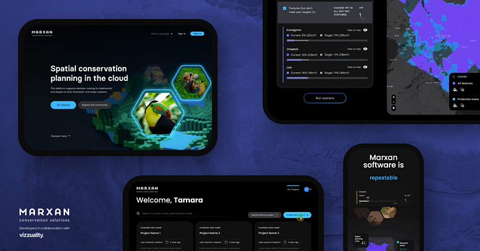
Spatial Intelligence for Conservation Planning
Marxan revolutionizes collaborative conservation planning in the cloud
Marena Smith
Jul 27, 2023
Communities Harness Mapbox Maps For Climate Action
Tech Matters debuts no-code Terraso solution for storytelling maps
Jul 20, 2023

Community Building through GIS and geoSTEM
Empowerment through Mapping
Rauland Sharp
Feb 28, 2023

Dynamic Camera Calibration: Accurately positioning and mapping road features using the Vision SDK
Dec 1, 2020
.jpg)
Mapbox joins partner ecosystem for Qualcomm Aware Platform
Ryan Leidigh
Mar 1, 2023

Fundraising Maps Convert Visitors to Donors
Apr 22, 2022
Stay in the loop
Provide your email to be notified about new posts!
We will keep fighting for all libraries - stand with us!
Internet Archive Audio

- This Just In
- Grateful Dead
- Old Time Radio
- 78 RPMs and Cylinder Recordings
- Audio Books & Poetry
- Computers, Technology and Science
- Music, Arts & Culture
- News & Public Affairs
- Spirituality & Religion
- Radio News Archive

- Flickr Commons
- Occupy Wall Street Flickr
- NASA Images
- Solar System Collection
- Ames Research Center

- All Software
- Old School Emulation
- MS-DOS Games
- Historical Software
- Classic PC Games
- Software Library
- Kodi Archive and Support File
- Vintage Software
- CD-ROM Software
- CD-ROM Software Library
- Software Sites
- Tucows Software Library
- Shareware CD-ROMs
- Software Capsules Compilation
- CD-ROM Images
- ZX Spectrum
- DOOM Level CD

- Smithsonian Libraries
- FEDLINK (US)
- Lincoln Collection
- American Libraries
- Canadian Libraries
- Universal Library
- Project Gutenberg
- Children's Library
- Biodiversity Heritage Library
- Books by Language
- Additional Collections

- Prelinger Archives
- Democracy Now!
- Occupy Wall Street
- TV NSA Clip Library
- Animation & Cartoons
- Arts & Music
- Computers & Technology
- Cultural & Academic Films
- Ephemeral Films
- Sports Videos
- Videogame Videos
- Youth Media
Search the history of over 866 billion web pages on the Internet.
Mobile Apps
- Wayback Machine (iOS)
- Wayback Machine (Android)
Browser Extensions
Archive-it subscription.
- Explore the Collections
- Build Collections
Save Page Now
Capture a web page as it appears now for use as a trusted citation in the future.
Please enter a valid web address
- Donate Donate icon An illustration of a heart shape
- Skip to main content
- Keyboard shortcuts for audio player

Middle East crisis — explained
The conflict between Israel and Palestinians — and other groups in the Middle East — goes back decades. These stories provide context for current developments and the history that led up to them.
How Iran and Israel became archenemies

Peter Kenyon

Emergency and security personnel extinguish a fire at the site of strikes that hit a building annexed to the Iranian embassy in Syria's capital Damascus on April 1. Iran blames Israel for the attack. Louai Beshara/AFP via Getty Images hide caption
Emergency and security personnel extinguish a fire at the site of strikes that hit a building annexed to the Iranian embassy in Syria's capital Damascus on April 1. Iran blames Israel for the attack.
ISTANBUL — Israel is on high alert for a possible attack from Iran, following an airstrike that hit the Iranian consulate in Syria two weeks ago and killed several senior Iranian military officers. Iran blames Israel for the attack, and has vowed to retaliate.

Iran's regional flashpoints are increasing. Here's what to know
Many countries have issued warnings to their citizens not to visit the region, as tensions flare and fears grow that an Iranian attack may be imminent — and the war in Gaza may spread.
Iranian leaders have been among the sharpest critics of Israel's military operation in the Gaza Strip. Tehran has made no secret of its praise for those who attack Israelis, including the Hamas-led attack that Israel says killed 1,200 people on Oct. 7.

U.S. drone strike kills a leader of an Iran-backed militia in Iraq
Israel compiled a video showing Hamas gunmen killing civilians, including babies, and burning corpses. Human Rights Watch verified some of the videos of the attack, and called on the International Criminal Court to investigate the attacks as war crimes.

People attend the funeral procession for seven Islamic Revolutionary Guard Corps members killed in a strike in Syria, which Iran blamed on Israel, in Tehran, April 5. Hossein Beris/Middle East Images/AFP via Getty hide caption
People attend the funeral procession for seven Islamic Revolutionary Guard Corps members killed in a strike in Syria, which Iran blamed on Israel, in Tehran, April 5.

Iranian officials accuse Israel of a deadly attack on Iran's consulate in Syria
Iran, however, wasted no time in hailing the Hamas attack as a "victory." Hours after news of the attack broke on Oct. 7, Iran's Foreign Ministry spokesman Nasser Kanani told Iran's ISNA news agency that "What took place today is in line with the continuation of victories of the anti-Zionist resistance in different fields, including Syria, Lebanon and occupied lands."
Iran blames Israel for the April 1 airstrike on Iran's consulate in Damascus that killed seven members of Iran's Revolutionary Guard Corps, including two IRGC generals . Israel has neither confirmed nor denied being behind the attack.
If Israel was responsible, it would be the latest in a long line of attacks against Iranian targets.
1979 was a pivotal year
While Iran was ruled by the Pahlavi dynasty for more than a half-century, Iranian-Israeli bilateral relations were far from hostile. Iran was one of the first Muslim countries to recognize the new state of Israel .

The killing of U.S. troops in Jordan raises specter of a wider war in the Middle East
Palestinians saw that recognition as a tacit international acceptance of what they call the "Nakba," or catastrophe — the forced dispossession and displacement of more than 700,000 Palestinians when Israel was created in 1948.
For its part, Israel was quick to establish ties with non-Arab states, including military and security cooperation with Iran.
Iran's 1979 Islamic revolution, though, sent relations between the two nations into a tailspin. Shah Mohammad Reza Pahlavi was ousted, and the new supreme leader of the Islamic Republic of Iran, Ayatollah Ruhollah Khomeini, pursued a policy of standing up to "arrogant" world powers. During his regime, the United States became known in Iran as the "Great Satan," and Israel as the "Little Satan."
Even so, limited cooperation between Israel and Iran continued into the 1980s. But later a hostile rivalry emerged as Iran built up and funded proxy militias and other groups in Syria, Iraq, Lebanon and Yemen. A shadow war between Iran and Israel grew over the years.
Iran's nuclear program is a main target
Iran's nuclear program — which it has always insisted is entirely peaceful — has been a primary focus of Israeli attacks. Tehran believes Israel and the U.S. introduced the Stuxnet computer virus in the early 2000s to target the centrifuges enriching uranium for Iran's nuclear program
A series of sabotage attacks continued into the 2020s, as Israel sought to damage Iranian nuclear facilities. Nuclear scientists were also targeted. President Donald Trump's decision to withdraw from the Iran nuclear agreement in 2018 was seen as a blow to Tehran and a victory for Israel.

Middle East
Iranian commandos seize an israeli-linked container ship near strait of hormuz.
Iran continues to insist that its program is 100% peaceful, although certain incidents, such as an unexplained discovery of uranium particles at sites Iran never disclosed to the United Nations nuclear watchdog agency, trouble critics who doubt Iran's motives.
With Iran firmly under the control of Islamist hard-liners, and conservatives leading Israel, there seems little likelihood of a return to cordial Iranian-Israeli relations anytime soon.
War by proxy
Iran has long backed armed groups around the region that target Israel as well as the U.S. military. The main one is Hezbollah in Lebanon, formed in the 1980s to fight the Israeli occupation in southern Lebanon. Hezbollah has been firing rockets into northern Israel since the Gaza war began in October.
Iran also supports Hamas, the armed Palestinian group that led the Oct. 7 attack on southern Israel that triggered the current war, which Gaza health authorities say has killed more than 33,000 Palestinians, mostly women and children, over the past six months.

Biden says Iran could soon attack Israel, and warns, 'Don't'
Iran also has provided support to Houthi rebels in Yemen, who have fired ballistic missiles at the Israeli resort town Eilat on the Red Sea, and attacked shipping vessels — attacks which the Houthi rebels say are in support of Hamas.
Iran supports the Syrian regime of President Bashar Assad, and Israel says Tehran uses Syrian territory to ship missiles and other weapons to Hezbollah in Lebanon. Israel has carried out numerous airstrikes in Syria to halt that flow of weapons, and said the Iranian general killed in the consulate strike was a key figure in that logistical chain.
Now, however, American and Israeli officials are warning of the risk of a direct attack by Iran against Israel. Iran's supreme leader, Ayatollah Ali Khamenei, has said the April 1 attack on the consulate building in Damascus, for which Iran blames Israel, was tantamount to an attack on Iranian territory. He has threatened that Israel "must be punished and shall be."
Israel has said that an attack from Iranian soil would be met with a direct response against Iran. That could trigger a major regional war.
U.S. officials say that they have sent messages to allies with closer ties to Tehran to urge Iran to exercise restraint. The U.S. officials noted that the U.S. has also relayed the same message directly to Iranian officials.
- Israel-Hamas war
IMAGES
VIDEO
COMMENTS
Welcome to OpenHistoricalMap! OpenHistoricalMap is an interactive map of the world throughout history, created by people like you and dedicated to the public domain. OpenHistoricalMap collaboratively stores and displays map data throughout the history of the world.
Learn History visually with Interactive 3D Maps, Timelines, Images, and Videos with HistoryMaps. Use the interactive map and timeline to learn where and when something happened. The beautiful images and videos make it even better.
Interactive historical map of the world, historical timeline, 20th century history. Learn about historical events, track border changes, visualize unions. Interactive historical maps - historical timeline - world history maps - territorial evolution of countries - world history atlas - 20th century history
Interactive detailed political map from ancient times to our days. Empires, kingdoms, principalities, republics
World History Maps website. Since finding complete world history maps has always proven to be a daunting task, we decided to start drawing some world history maps and share this content for free. Our atlas of the World History Maps includes a series of historical maps, divided into five eras: prehistoric, primeval, ancient, medieval, and modern ...
World History Maps & Timelines. Kingdoms, Battles, Expeditions. Comparative History, Political, Military, Art, Science, Literature, Religion, Philosophy. Maps based on vector database. Tweet. Tumblr is a place to express yourself, discover yourself, and bond over the stuff you love. It's where your interests connect you with your people.
4000 year narrated map animation: 3000 BCE-1000 CE. Free online book. 22 languages. No ads.
Map of the Ancient World. This interactive political map by World History Encyclopedia offers a large-scale overview of the ancient world across all time periods. Choose a date and see what the world looked like. It focuses on the Mediterranean, but also covers other parts of the world. Note: This is a work in progress!
The TimeMap of World History is designed to make all the world's history easily accessible, so that we can understand each others' pasts better. The Atlas contains 1,000+ maps covering world, regional and country histories, while the Encyclopedia offers the opportunity to investigate topics in more depth. Explore our world's history.
Alexander the Great was a king of the kingdom of Macedon. He had created one of the largest empires of the ancient world by the age of thirty. More... Early History. Period from first states to Classical Greece More... Second Punic War. The Second Punic War, also referred to as The Hannibalic War, was the second of three wars between Carthage ...
Each map contains a wealth of information and stories, so to have such a wide range of topics covered is a fantastic resource. I chose to use the maps in a BBC video because they are a very clear way to show changing borders in Europe and there were so many dates available through history. It was the biggest and clearest range of maps I could find.
The easy-to-use getaway to historical maps in libraries around the world. Discovering the Cartography of the Past. The easy to use gateway to historical maps in libraries around the world. Find a place Browse the old maps. Follow us on. Looking for Google Maps API Alternative? World Related places: Region. Africa; Region. Antarctica; Region ...
The free online history encyclopedia with fact-checked articles, images, videos, maps, timelines and more; operated as a non-profit organization.
Interactive World History Timeline and Map. 500 BCE - 500 : 0. events
The Maps page has a list of my world history maps. For convenience, the maps are divided into 5 eras: Prehistoric, Primeval, Ancient, Medieval, and Modern). * Read About the Maps for licensing and usage information! The Sources section is a list of references for the information depicted on the maps. Currently stored on 3 long pages, I plan to ...
Chronas.org is a history map application with over 50 million interconnected data points. Chronas.org is a history map application with over 50 million interconnected data points ... Clean & Fast Only map borders and labels. Intermediate Borders, labels and a maximum of 2000 markers per year. Complete Epics in timeline and a maximum of 5000 ...
We have over 1.6 million searchable images in our collection. Keyword search queries our database for map names, atlas names, publishers, dates, and locations that match your keywords. Results are divided into United States (Maps, Atlases, Bird's Eye Views, Illustrations & Directories) and World (Maps, Atlases & Special Collection) categories.
1000AD. 1500AD. 2000AD. Explore any date in the history of human civilization from 3000BC to today.
Create your owncustom historical map. Create your own. custom historical map. Make a map of the World, Europe or the United States in various chronologies. Color code countries or states on the map. Add a legend and download as an image file. Use the map in your project or share it with your friends. Free and easy to use.
Welcome to Histography. where every dot is a historic event from wikipedia. You are now viewing history from 1600 - 2000. Resize the bottom bar to view any time period or era. Got It. This screen will show you selected events. throughout history. Scroll through the events on the left. The more you move, the further you will delve into history.
The American map collector is among the well-known map collectors and cartographers in the world. His 63,000-strong historical map collection is perhaps the largest resource available on the web for the public. Here you can find rare maps from the 16th through the 21st Century of America, North America, South America, Europe, Asia, Africa ...
Mapbox. Aug 18, 2022. There's always a 'story' in history —or in the case of HistoryMaps, hundreds of stories! An immersive, educational site that invites readers to explore history through time and geography, HistoryMaps is a beautiful example of using interactive maps as a storytelling medium. I connected with the creator of ...
The Wayback Machine is an initiative of the Internet Archive, a 501(c)(3) non-profit, building a digital library of Internet sites and other cultural artifacts in digital form. Other projects include Open Library & archive-it.org .
Tehran believes Israel and the U.S. introduced the Stuxnet computer virus in the early 2000s to target the centrifuges enriching uranium for Iran's nuclear program. A series of sabotage attacks ...